Coast & Geodetic Survey Topographic Sheets (T-sheets)
The U. S. Coast Survey, renamed as the U. S. Coast & Geodetic Survey in 1878, mapped the Puget Sound nearshore at a reconnaissance level in the 1840s, and then at a more detailed scale (1:10,000 and 1:20,000) in the following decades. The agency created two map series: topographic sheets, commonly referred to as "T-sheets, concentrated on intertidal and supratidal areas, and hydrographic sheets, or "H-sheets," showed soundings. The maps available from this site are the earliest detailed (1:10,000 or 1:20,000 scale) T-sheets for the Puget Sound nearshore.
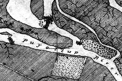
 "Detail
from topographic sheet 1453, “Topography of Commencement
Bay, Puget Sound, Wash. Ter.” Surveyed in 1877 at a scale of
1:10,000 by Eugene Ellicott, it shows an agricultural field
on the river’s left bank surrounded by salt marsh.
For help with interpreting T-sheets, Shore
and Sea Boundaries, Volume 2, by A. L. Shalowitz (1964),
is the standard reference on early Coast Survey mapping. See mapping
methods for information on how we used T-sheets in
mapping pre-settlement conditions in the Puget Sound area.
How we Georeferenced T-sheets
Early T-sheets were surveyed relative to a an obsolete datum. Typically the sheets show latitude and longitude graticules in the early, local, Puget Sound Datum (PSD), and a later update to the North American Datum (NAD). We calculated a datum shift to convert to current datums (e.g., NAD27, NAD83).
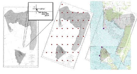
 Steps in the process of georeferencing
topographic sheet 1871, “Topography of Gulf of Georgia,
Village Point to Base of Sandy Point. Surveyed in 1888 at a
scale of 1:10,000 by J. J. Gilbert.

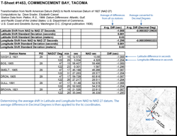
To calculate a datum shift, we used "datum difference" tables
for survey stations around most of Puget Sound (Patton, 1999)
which provide X and Y values for calculating the shift from
NAD to NAD27. An overall datum shift
is determined for a T-sheet by averaging the shift from
survey stations within or nearby the area represented on the
T-sheet, and making a first order polynomial transformation to
rectify the T-sheet into UTM Zone 10N NAD27 projection.

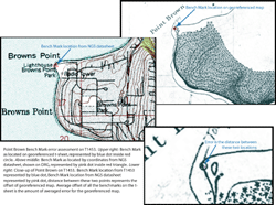
To assess accuracy with which each T-sheet was registered, we compared National Geodetic Survey (NGS) benchmarks located on the T-sheet to published NGS benchmarks that were retraceable to the time of the surveyed T-sheet. We used only those benchmarks established prior to the original T-sheet survey and not later remounted.
Surveyors recorded these benchmarks on most T-sheets. However, in a number of cases only one benchmark could be retraced to the time of the original T-sheet survey, and there are some cases where no benchmarks could be found that correlated with the NGS published benchmarks.
How we Digitized T-sheets
We digitized on-screen at an average scale of 1:1,500, generally digitizing everything on a sheet, except for a few sheets where information extended farther inland; in those cases we digitized information within 500m of the nearshore. We did not digitize topographic lines, which topographers sketched by eye. We attempted to keep as closely as possible to each topographer's intent, using each surveyor's map categories to attribute our digitized coverages, and with a minimum of translation into modern terms.
![]() Download a
vector geodatabase of edge-mapped T-sheets for the Puget
Sound region (includes metadata).
Download a
vector geodatabase of edge-mapped T-sheets for the Puget
Sound region (includes metadata).
View T-sheet geodatabase metadata.
T-sheet Data for Other Regions
- San Francisco Bay area (georeferenced T-sheets and vector data)
- Florida Everglades area (georeferenced T-sheets)
- Hawaii Coastal Geology Group (georeferenced T-sheets)
- Coastal United States (T-sheets and nautical charts, not georeferenced)
- Coastal United States (vector coastline from T-sheets)
Acknowledgments
In developing methods for referencing T-sheets we benefited from discussions with Jennifer Burke (NOAA Fisheries and University of Washington), Alan Carter Mortimer (Point No Point Treaty Council), and David Doyle (NGS). David Doyle generously provided transformation information for areas where data from Datum Differences were insufficient.
References
Daniels, R. C. and R. H. Huxford. 2001. An error assessment of vector data derived from scanned National Ocean Service topographic sheets. Journal of Coastal Research 17: 611-619.
Patton, R. S., 1999. Datum Differences: Atlantic, Gulf, and Pacific Coast of the United States. U.S. Department of Commerce, U.S. Coast and Geodetic Survey, Washington D.C. (Original publication: 1936).
Shalowitz, A.L. 1964, Shore and Sea Boundaries, Volume 2, U.S. Department of Commerce, U.S. Coast and Geodetic Survey, Washington, DC. http://chartmaker.ncd.noaa.gov/ocs/text/shallow.htm.