Snohomish
River
1933 Aerial Photos
To Find and Download Orthophotos:
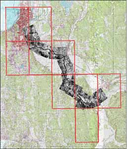
Select an orthophoto tile on the reference image (right). A close-up image will appear in a viewer window to the right, with links to download a full-sized, high-resolution version of the image.
This set includes air photos covering the Snohomish River. Data is organized and named by quarter quad (red grid at right) and is zipped into a UTM ZONE 10N NAD27 and a UTM ZONE 10N NAD83/HARN .zip file that includes a geo-tiff (.tif) and metadata (.html).
The reference image (right) shows the photo mosaics draped over contemporary topo maps and shaded relief. A hi-res poster of this reference image (right) may be downloaded in .pdf format for educational and personal use.